"APPARE!" FUJI TOZAN
The admiration in climbing Mt Fuji.
Outline
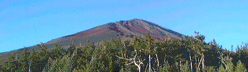
Mt Fuji is the highest mountain in Japan at a total of 3776 metres, located approximately 100 kms south-west of Tokyo. The official climbing season is July and August, but climbing is still possible until the middle of September if it does not snow, but please keep in mind that all official shops and most of huts close at the end of August. Mt Fuji is too dangerous in all other seasons to climb with the exception of professional mountaineers.
There are officially four routes for climbing Mt Fuji, making climbing possible to people of all ages. In fact, approximately 300,000 people attempt the climb annually. There are however matters which require attention. Mountain sickness is something which affects some people due to the high altitude above sea level, in which case it is advised to descend immediately.
Furthermore, the summit around daybreak at this time of year is normally less than 5 degrees Centigrade in addition to strong wind, so adequate protection against the cold is necessary. On other days, the day time temperatures can also get very hot, so adequate drinking water is highly recommended. In essence, bad weather, strong winds and lightning can be very dangerous, not to mention falling rocks, sunstroke, cold, heart failure and other accidents which have led to death.
Accommodation on the climb are in the form of huts which normally charge about 7000 yen. Closer to the summit, the scenery can be second to none when the weather is fine. Let's enjoy mountain climbing!
Shops on the summit open from about 3.30 a.m. in July and August but may close during the last five days of the season. Sunrise is generally between 4.30 and 5.00 a.m., when many shout the Japanese phrase "Banzai", a word of celebration and hope for longevity.
A detailed time schedule for buses can be found at:
Fujikyu
Necessary Equipment
Trekking shoes, gloves, rain gear, towel, drinking water, hat, walking
stick, first aid, snacks, change of clothes, sunglasses, toilet paper,
flashlight and extra clothes for protection against the cold.
Route Explanation
The crater has a diameter of approximately 800 meters, so please keep in mind the maps are not to scale.
Blue line : Climbing & Descending Trail.
Red line: Descending Trail.
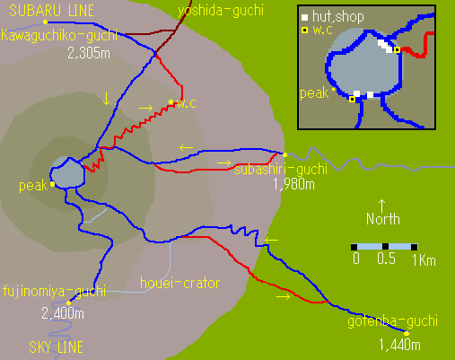
Times indicated below are for mountain climbers, so please allow extra time."Guchi" is Japanese for "entrance".
Yoshida Trail (Kawaguchiko-guchi, Fuji Subaru Line)
The altitude of the 5th station's start point is 2305m. (7560ft)
Time required to reach the summit is approximately five and a half hours. Although this route is the most crowded, there are a lot of mountain huts along the way. Please be careful closer to the peak on descent at the 8th station so as not to use the Subashiri trail, but instead keep to the Yoshida Trail (Kawaguchiko,).
Subashiri Trail (Subashiri-guchi)
The altitude of the 5th station's start point is 2000m. (6560ft)
Time required to reach the summit is approximately five hours. By using this less crowded route, you will be able to enjoy the tranquillity of the mountain, but as this route connects to the above Yoshida Trail(Kawaguchiko) at the 8th station, please be sure to pay attention on descent.
Fujinomiya Trail (Fujinomiya-guchi)
The altitude of the 5th station's start point is 2400m. (7872ft)
Time required to reach the summit is approximately four and a half hours. This route is the easiest of the four routes, but it is a little difficult to see the sunrise, in which case extra time should be allowed to reach the summit in time.
Gotenba Trail (Gotenba-guchi)
The altitude of the 5th station's start point is 1440m. (4723ft)
Time required to reach the summit is approximately six hours twenty minutes. As the starting point for this route is considerably lower, please keep in mind the additional time necessary to reach the summit. Due to the fact this is one of the less popular routes simply due to the distance, please also be aware there are only few mountain huts on this route.
Going around the crater
You can walk around the crater of Mt Fuji which is approximately 3 kms and takes about 90 minutes, but should be avoided at times of bad weather.
Special thanks to Mr. Brett Cumming.
link
Official Web Site for Mt. Fuji Climbing
GORAIKOUKAN (Lodge Alt.3450m)
Fujikan (Hut Summit)